"Hsinchu Secret" Zhisheng Maotai Mountain Trail|Climbing, maple viewing, bathing, and camping will make you satisfied at one time
Jianshi Township, Hsinchu County is a must-see maple viewing spot for tourists every autumn. There are several beautiful maple viewing trails here, such as the national-level Xia Kaluo Ancient Road, God's Tribe Simacus, etc. Today I would like to recommend one to everyone. Zhisheng Maotai Mountain Trail located in Xiuluan Village, whether you are a one-day mountaineering or two-day camping friend, let me introduce the trail's route, traffic, history, pre-trip preparation and gameplay for you one by one. !
.jpg)
Introduction to Zhisheng Maotai Mountain
Location (GPS): Can navigate to Warship Rock Suspension Bridge (google map)
Altitude: 800 meters (mountain trail) - 1789 meters (triangle point)
Full-length distance: 3.4 kilometers one-way (6~7 hours round-trip)
Difficulty: ●●●○○
Zhisheng Maotai Mountain belongs to the branch of the Snow Mountain Range. The trail starts from the Warship Rock Suspension Bridge. Although it is only about five kilometers long, most of it is uphill due to the fast climb of 1,000 meters above sea level. The first 1/3 of the journey is stone steps. The last 2/3 is the original dirt road, which is a little challenging route. Due to the strategic location, the trail can witness the ruins of the management of the aborigines during the Japanese occupation, forts, trenches, stationing houses, etc. In autumn, a large area of red maple trees on the riverside is amazing. In addition, you can walk in the direction of Xiulan and Taigang Yexi Hot Springs under the suspension bridge. There are also many camping areas and homestays nearby, which are worth spending two days. Time to slowly explore the place.
Latest departure time:
4/2 (Saturday) Hsinchu Zhisheng Maotai Mountain Trail One Day Tour | Hidden Mountains in the Valley (Registration is open)
Walking route:
Climbing Entrance (Warship Rock Suspension Bridge)---Aiyong Supervision Office---Aiyong Dispatch Station---Cannon Position Aiyongliao---Tun Wild Fortress Site---Zhisheng Maotai Mountain
%20(1).jpg)
▲There is a parking place at the entrance of the mountain, and a fee of 100 per time is required
%20(1).jpg)
▲There are toilets at the entrance of the mountain, 10 yuan at a time, remember not to liberate anywhere in the mountains and forests (No Trace Mountain Forest Reference Code)
%20(1).jpg)
▲Start at the Warship Rock Suspension Bridge, the maple and red will be very spectacular in autumn! The large stone on the banks of Shiraishi Stream is called Warship Rock because it is shaped like a large warship sailing into the valley.
%20(1)(1).jpg) ▲Warship Rock Suspension Bridge Entrance Sign
▲Warship Rock Suspension Bridge Entrance Sign
%20(1)(1).jpg)
▲The geology of the warship rock is the Wenshui layer, which is composed of light gray to dark gray thin layers of firm fine sandstone and thin layers of gray to dark gray shale or sandy shale
%20(1).jpg) ▲A pavilion on the Warship Rock Trail
▲A pavilion on the Warship Rock Trail
%20(1).jpg)
▲There are many Atayal totems on the Warship Rock Suspension Bridge
%20(1).jpg)
▲ Overlooking Yufeng Valley from the suspension bridge, the color of the stream is very beautiful
%20(1).jpg)
▲Taigang River and Baishi River converge to Yufeng River, which is one of the upper tributaries of Dahan River
.jpg)
%20(1).jpg)
▲The first third is stone steps
%20(1).jpg)
▲There are chairs along the road to rest and shade, which is suitable for summer
%20(1).jpg)
▲The last two-thirds are paved with primitive dirt roads and pine needles. Be careful that it will be a little slippery. It is recommended to wear hiking shoes and take trekking poles.
%20(1).jpg)
▲There are many forks on the way, in addition to doing your homework online, remember to download offline maps or ask a guide
%20(1).jpg)
▲Aiyong Dispatch Station, where there are complete relics of stone walls, take you into the history of the Japanese occupation period
%20(1).jpg)
▲The hole in the wall is a gun hole. Standing in the same position, imagining the days of being ruled in the past, the mood is really mixed!
%20(1).jpg)
▲The trench during the Japanese occupation period was as high as one person, and it was a bunker to protect soldiers from artillery fire during wars
%20(1).jpg)
▲The triangle point of Maotai Mountain in Zhisheng, 1789 meters above sea level, there is no outlook, but there are other paths on the top of the mountain to go to other hills (to Huli Mountain, Yufeng Bridge, Marico Bay)
%20(1).jpg)
▲There is an open space at the triangle point to rest, make tea, and cook things. Remember that the garbage does not fall to the ground
%20(1).jpg)
▲ There are also routes at the triangle point to go to other hills
%20(1).jpg)
%20(1).jpg)
▲There are various mushrooms on the trail
%20(1).jpg)
▲ There are beautiful cherry blossoms at the entrance of the mountain
transportation
1. By car: Go south and take the Zhulin Exit of "National Highway No. 3" and get off at the interchange, drive "120 County" towards Jianshi, cross Jianshi Bridge at Neiwan and turn right to "Zhu 60 Township Road", pass Yu Lao to Xiu Go in the direction of Luan tribe, destination Warship Rock Suspension Bridge. (Gunshipyan Suspension Bridge click here to display on google map)
2. No mass transit
3. Chartered car: please contact Orange Cat Chartered Car (click here)
history
During the Japanese occupation period, the five-year plan to manage the Tibetans (1910-1915) was carried out, and the plan to control the aboriginal people. Yao, Wu Dao Nenggan, Sanguang, Yeheng, etc., as well as Baling, Guanghua, etc. along the Hehuan River (Sanguang River), the Atayal people living in various places resisted very fiercely, so the Japanese army set up three main forts (Li Dongshan, Zhishengmao) Taishan Mountain and Malun Mountain), which control the mountainous areas of Jianshi Township and Fuxing Township today, so you can see sites such as forts, trenches, gun holes, etc. on the mountains, which is of great historical and educational significance. References:Time Tunnel Traveling in Balai - Gao Lizhong、Institute of Taiwan History, Academia Sinica - Lin Yihong, Wang Huijun,
Preparation before departure
1. Regardless of whether you have a guide or not, you still have to do your homework (recommended hiking biji, a good website for mountain climbing homework)
2. Usually, you need to know your own physical condition. You can't help but strengthen yourself on the mountain. You must also be able to master your physical condition. When you need to retreat, you must retreat. When you need to rest, you must rest.
3. The equipment is not too troublesome. Bring what should be brought, buy what should be bought, and rent what should be rented (click here what should I bring for climbing? )
4. Maintain physical fitness on weekdays, commute by bicycle, take stairs instead of stairs, running, swimming, cycling, climbing suburban mountains, etc.
5. Safety is the first, and the summit is second. Remember to check the weather forecast and the accumulated rainfall before departure (Central Meteorological Administration website (click here)
6. Remember to let your friends and relatives know your itinerary and try not to climb solo
7. Spare clothes, first aid kits, rain gear, headlights, etc., some things that may not be used should still be brought
Other ways to play
1. Camping: You can choose from many camping areas in Jinping and Yulao areas, or you can also camp if there is open space under the river bed under the Warshipyan Suspension Bridge. Friends who want to be more leisurely can plan a two-day trekking and camping on Zhisheng Maotai Mountain tour. Remember to pay attention to the weather and accumulated rainfall when camping by the creek
2. Bathing: Walking along the Taigang River, there are Xiuluan Hot Spring and Taigang Hot Spring. It is recommended to visit during the dry season (December-February). You can also camp if there is an open space nearby (click here for a detailed route for reference)
3. Appreciating the maple: The maple red festival in the entire valley is very spectacular in December every year. Friends who like maple trees or love photography, don't miss it!
4. Other nearby mountaineering routes: For advanced routes, you can challenge to climb one more Huli Mountain, the route reference (click here Huli Mountain + Zhisheng Maotai Mountain)
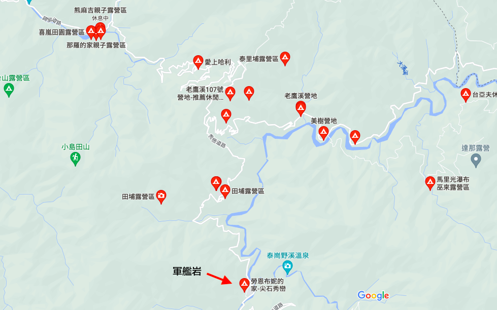
▲There are many great camping areas near Jianshi Township, Hsinchu, I recommend it to friends who want to try camping
click here:let's go!

%20(1).jpg)
